severe weather

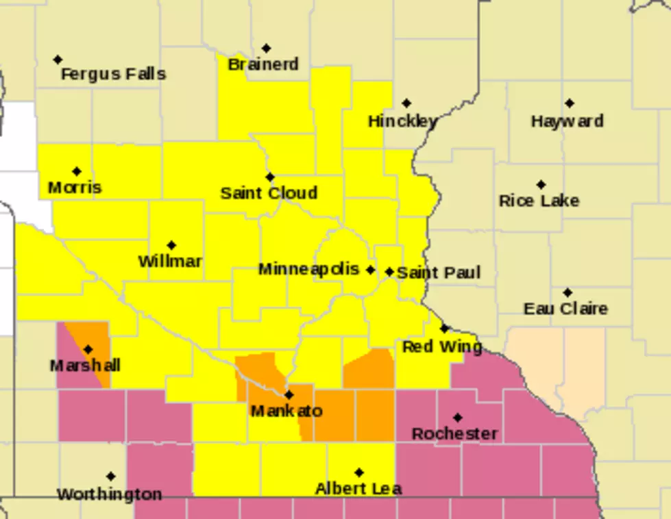
Flood Watch SE Minnesota
Another round of thunderstorms is expected across portions of the Upper Mississippi River Valley Friday afternoon through early Saturday morning. About 1-3 inches of rainfall is possible with perhaps some localized higher amounts. This expected heavy rainfall, coupled with saturated and some already flooded ground from heavy rainfall last night, could cause some flash flooding, issues, including r
Storms Possible Wed. PM
Xcel Energy crews are preparing for potential thunderstorms and severe weather today that could include damaging wind, hail and flash flooding. In preparation for the severe weather, Xcel Energy has about 450 crewmembers and contractors in the metro area and outstate Minnesota who are ready to respond to potential electric outages...
Severe Thunderstorm Watch
A severe thunderstorm watch is in effect for a good portion of southern Minnesota until 4AM. Large hail, damaging winds, frequent lightning, heavy rains are possible. A tornado can't be ruled out as well. Be prepared to move to a place of safety and relay severe weather sightings to local law enforcement...
Severe Weather Moving Through
A number of severe thunderstorm warnings are in effect for southern Minnesota. Also a Tornado watch is in effect until 1AM Monday. After the storms move through south eastern Minnesota more storms will be moving down into the area again from around the Wilmar area...
Tornado Watch for Southern Minnesota
The National Severe Storms forecast center has issued a Tornado Watch in effect until 1am for the following counties: Anoka, Blue Earth, Brown, Carver, Chippewa, Dakota, Faribault, Freeborn, Goodhue, Hennepin, Kandiyohi,  Lac Qui Parle, Le Sueur,  Martin, Mcleod, Meeker, Nicollet,          Pope, Ramsey, Redwood, Renville, Rice, Scott, Sherburne, Sibley, Stearns,              Steele, Stevens, Swift
Watch the Sky
Watch the Sky
Watch the Sky
The National Weather Service says that there is a slight risk of severe weather over most of southern Minnesota for Wednesday evening and a marginal risk on Thursday. After that for the rest of the weekend only scattered storms are expected...
Severe Thunderstorm Watch for Southern Minnesota
The national Severe Storms Forecast center has issued a severe thunderstomr watch in effect until 10pm for a large portion of southern Minnesota. Counties included are: Blue Earth, Dodge, Faribault,  Fillmore, Freeborn, Goodhue, Houston, Le Sueur, Martin, Mower, Olmstead, Rice, Steele, Wabasha, Waseca and Winona Counties...
Another Round of Severe Storms Possible Tuesday
The National weather service is reporting that there is an Enhanced Risk of severe thunderstorms this afternoon, through tonight generally west of Interstate 35 and a slighter risk, to the east into west central Wisconsin. Large hail and damaging winds are possible with the line of strong thunderstorms that is expected to march east across the area...
Strong Storms Possible Monday Afternoon
Some strong thunderstorms have moved through Waseca, Steele and Into Olmstead Counties Monday morning and more are moving from the Southwest to the Northeast. Some severe weather is associated with these storms. There is a risk of scattered severe storms to develop with the moist air over the area...

Load More Articles